The Northern School of Permaculture
You are here
Ordnance Survey Grid References
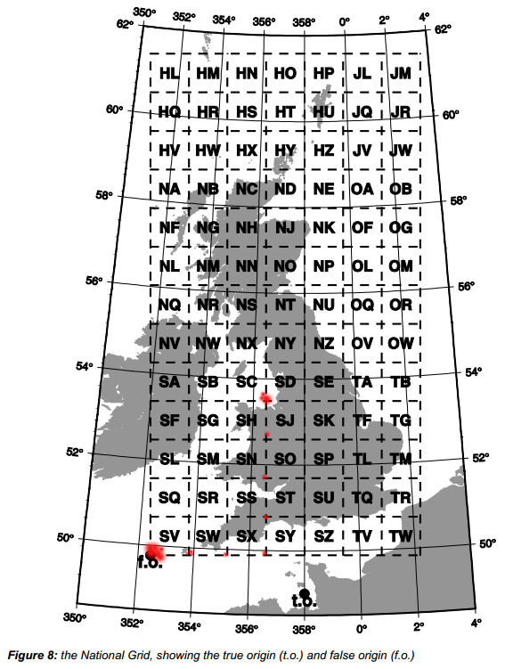 The UK Ordnance Survey (OS) divides the British Isles into 500km squares designated S,N,H,O,T and subdivides these into 100km squares, allocating a second letter to each. Every 100km square has a unique pair of letters - for example, Todmorden can be found within the area named SD.
Grid references have their datum, or "origin", at the South West corner of the square, usually this is the bottom left hand corner (when you have north at the top of the map). To locate a feature within a square on the map, the first part of the reference is distance traveled in an easterly direction from the datum (called the "easting"), and the second part is the distance traveled in a northerly direction (the "northing"). References have a degree of accuracy dependent on the number of digits used.
Examples:
SD 94 21 gives a 1km square containing Dean Royd Farm, being 94km east and 21km north of the south-western corner of grid square SD.
SD 940 212 gives a 100m square containing Dean Royd Farm, 94.0km east and 21.2km north of the same datum.
SD 94026 21179 gives a square metre inside Dean Royd Farm yard, 94026m east and 21179m north of datum.
Note: sometimes numbers are used instead of the two-letter grid code.
Example: the datum point of SD has an easting of 300km and a northing of 400km from the OS "origin". The national, "OS", grid reference for Dean Royd Farm may then be written as 394026 421179.
There is much more information at the Ordnance Survey website.
Theme by Danetsoft and Danang Probo Sayekti inspired by Maksimer